
Favorite Green Mountain Trails
Boulder, Colorado
Prepared in conjunction with
Boulder High School Class of 1963 40th Reunion
by Hu McCulloch
- Maps
-
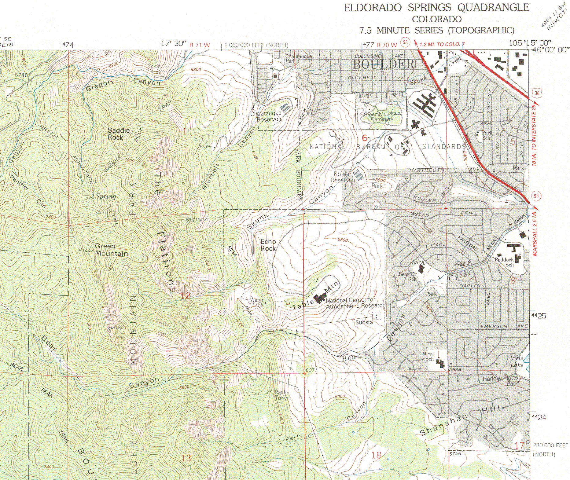
Topo Map of Green Mountain. (1.5 MB)
Baseline Road doesn't show on this map, but is just a few feet north of
its top edge. This doesn't show many of the trails, but it gives the
topography. Red grid, when regular, = 1 mile square. To view full scale
(2 screens wide) using MS Explorer,
rest cursor on map and click on "expand image" icon that eventually appears in
lower right corner.
- Topo Map of Flagstaff and points
north. (2.8 MB)
-
Boulder City
Parks map of Green Mountain trails.
Gives the trails and regulations, but not the
topography. Click on SW portion for Green Mountain area, then on hot
spots for detailed maps and trail comments. Details printable with
Adobe Acrobat Viewer.
- Trails
- Greenman Trail
Drive up Flagstaff Mountain Road to Flagstaff Road Trailhead
parking area in saddle between
Flagstaff and Green Mountain, just before the fork in the road
that takes you either up to the Flagstaff summit (right) or
down the back of Flagstaff or Green Mountains (left). This is
point "6748" in the upper left hand corner of the topo map, and
is called "Realization Point" on one of the Boulder Parks map details.
Scramble down hill to creek, pick up "Ranger Trail", follow 0.3
mile to shelter, go around shelter to left to continue another 0.3
mile to E.M. Greenman trail (left fork, called "Green Mountain Trail"
on topo). Proceed past Spring on topo
(a reliable source of water in 1963, but barely running in 1980), and
on up to summit saddle (just over the first "e" in Green Mountain
on the topo map). There the trail turns right to ascend the summit,
but first follow the well-beaten path to the left (not on
maps) to the Scenic Front Ridge Overlook. Return to saddle and
ascend a few switchbacks to the summit.
- Saddle Rock Trail
Drive up Baseline Road to where it crosses Gregory Creek and then
turns sharply right to ascend Flagstaff. After bridge, instead
turn left on dirt road up Gregory Canyon to Baseline Trailhead
("Picnic Area" just over Canyon in "Gregory Canyon" on topo
map.) To south of parking area, pick up Saddle Rock Trail, which
goes up past Saddle Rock and then picks up the Greenman trail below
the Spring. Don't miss
Sam's Spot on this trail.
- Royal Arch/Bluebell Canyon Trail (My favorite!)
Drive or walk south past Chatauqua to Bluebell Shelter trailhead
("Picnic Area" just above "bell" in "Bluebell Canyon" on topo). Go southerly to
pick up Royal Arch Trail. (See Boulder Parks map -- not on topo.)
Follow this westerly up Bluebell Canyon
between the 3rd and 4th Flatirons. When Royal Arch Trail abruptly turns
southerly to follow grade, instead leave trail and just head straight
uphill, westerly, to front ridge of Green Mountain, near the last "n" in
Green Mountain on the topo map. Then follow ridge northly to
Scenic Front Ridge Overlook mentioned above, proceed to
summit saddle, and pick up the final part of the Greenman Trail
to summit.
If you just go uphill, you can't miss the ridge and
then the Scenic Front Ridge Overlook, but don't try to descend this trail until you are
familiar with ascending it, or you may end up descending a
Flatiron by mistake!
- Gregory Canyon/Greenman trail
To make the Greenman trail more of a workout by adding
900 feet of ascent to it,
start from Baseline Trailhead, and proceed
westerly up Gregory Canyon trail to pick up the Ranger/Greenman
trail just below the Flagstaff Mountain Trailhead. Caution --
Gregory Canyon has little shade, and can be hot and dry, so bring
water, a hat, and start early. Note small lizards basking on rocks!
- There is a connecting trail from Baseline Trailhead to
Bluebell Shelter, if you want to park at one and make a loop. Enjoy!
- Notes
-
I have never encountered a
rattlesnake, bear, or mountain lion
on Green Mountain, but they probably exist. Keep your eyes open and
watch where you step or reach. See
Steve Thompson's site for prairie rattler photos and
.WAV file of rattle. Note that in 1999, a mountain lion attacked
an adult male runner in Bear Canyon, which extends from NCAR up the
south side of Green Mountain. See Boulder Parks website for
bear and mountain lion encounter etiquette tips, and be sure to take along a succulent hiking companion!
- Out-of-county cars must now have
daily parking pass for these
trailheads, available for $3/day at Gregory Canyon (Baseline) and Realization Point trailheads
and other points (self-service).
Bulletins
Portions of Mesa Trail near NCAR closed 7/16/03 due to bear encounters!
Trail restrictions lifted 7/21/03; bear demise euphemised.
Return to top of this page.
Up to Boulder HS 40th Reunion Page
Green Mountain photo courtesy
Boulder CVB
If you have trouble accessing this page, contact webmaster Hu McCulloch at
mcculloch.2@osu.edu
Page last revised 7/21/03